Background
Sky Revolutions was tasked with delivering precise volumetric data for Palmer Birch, who required a detailed analysis of a lake and its surrounding landscape. The goal was to provide a 3D spatial model that would offer a comprehensive view of the site, aiding the client in decision-making and land management.
Project Requirements
The client’s key requirements were:
- Collection of accurate volumetric data to assess land and water features.
- Development of a 3D model that could be explored from multiple angles.
- Use of a cost-effective and efficient method that could be implemented without disrupting the site.
Methodology
-
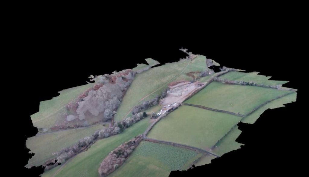
Data capture with eBee drone:
- Sky Revolutions deployed a long-range eBee drone to capture high-resolution photographs of the lake and surrounding landscape.
- The drone’s advanced imaging capabilities allowed us to collect multiple photographs from varying angles to ensure a detailed visual and spatial analysis of the area.
-
Data processing using Pix4D:
- Once the aerial images were collected, we processed the data using Pix4D, a powerful photogrammetry software.
- Pix4D allowed us to stitch the photographs together, creating a high-definition 3D spatial model of the lake and its surrounding land features.
-
3D model creation and analysis:
- The final 3D model provided the client with a comprehensive view of the landscape, allowing them to examine specific areas, focus on critical features, and make informed decisions.
- The model’s high level of detail also allowed for accurate volumetric calculations, enabling the client to analyse changes in the landscape, such as the volume of water in the lake or potential erosion areas.
Results
The client was able to:
- Obtain precise volumetric data quickly and cost-effectively, compared to traditional methods.
- Gain a full understanding of the lake’s structure in the context of its surrounding terrain.
- Utilise the 3D model for enhanced decision-making, including future land management and development plans.
The use of aerial drone technology significantly reduced the time and effort required to gather the data, while delivering a highly detailed and accurate model.
Conclusion
Sky Revolutions successfully delivered a detailed 3D spatial model and volumetric data for the client, showcasing how drone technology can be an effective tool for complex land and water feature analysis. This project highlighted the efficiency and accuracy of drone imaging in generating data that supports clear, informed decision-making.
Interested in learning how volumetric data and 3D spatial modeling can benefit your project? Contact our team of experts today to discuss how we can help you achieve detailed and accurate land analysis through aerial drone technology.