Accurate, detailed topographic surveys for every project – delivered efficiently using cutting-edge land and aerial technology
At Sky Revolutions, we specialise in delivering high-accuracy topographic surveys for a variety of industries, including construction, civil engineering, and environmental projects.
Whether you need precise land surveys for development, planning applications, infrastructure design, or flood risk assessments, our expert team ensures that every feature is captured with precision using the latest surveying technology.
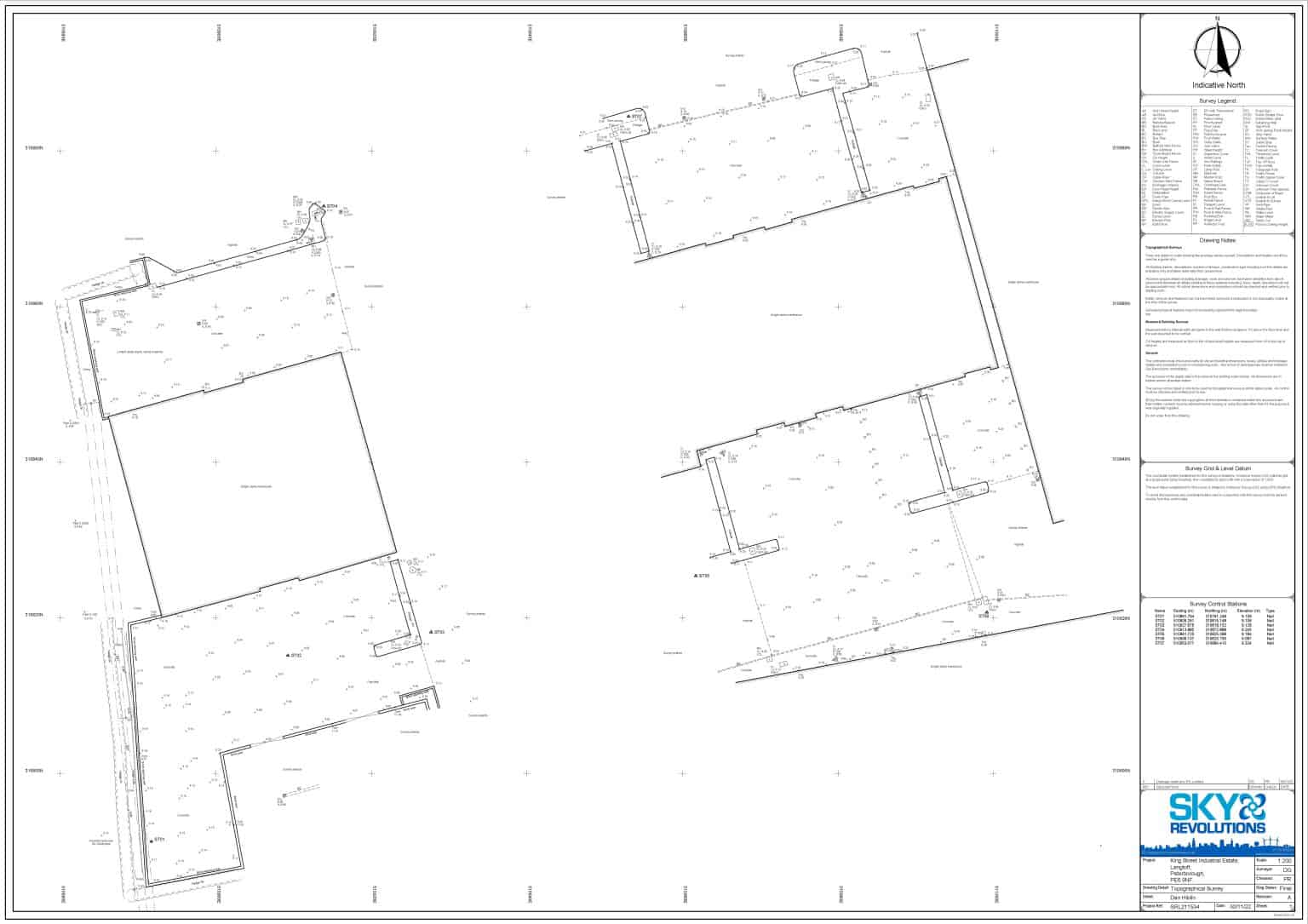
Topographic surveys provide vital information that supports planning and decision-making in many sectors. Sky Revolutions’ surveys capture detailed data on site features, including boundaries, levels, structures, trees, and water features. Common uses of our topographic surveys include:
If you’d like to discuss how topographic surveys can support your specific project, contact our team to learn more.
AERIAL TOPOGRAPHIC SURVEYS
With decades of experience in both aerial and land surveying, Sky Revolutions is a trusted partner for topographic surveys that meet the highest standards of accuracy and efficiency. From data capture to final reporting, we provide the precise data you need to make informed project decisions with confidence.
Our aerial topographic surveys are ideal for large, hard-to-reach sites or projects requiring comprehensive landscape data. Equipped with advanced sensors, including LiDAR and photogrammetry tools, our drones capture ultra-high-definition images to create accurate 3D models.
These aerial surveys minimise the need for on-site personnel, enhance safety, and support faster data collection, making them an excellent choice for large or complex terrains.
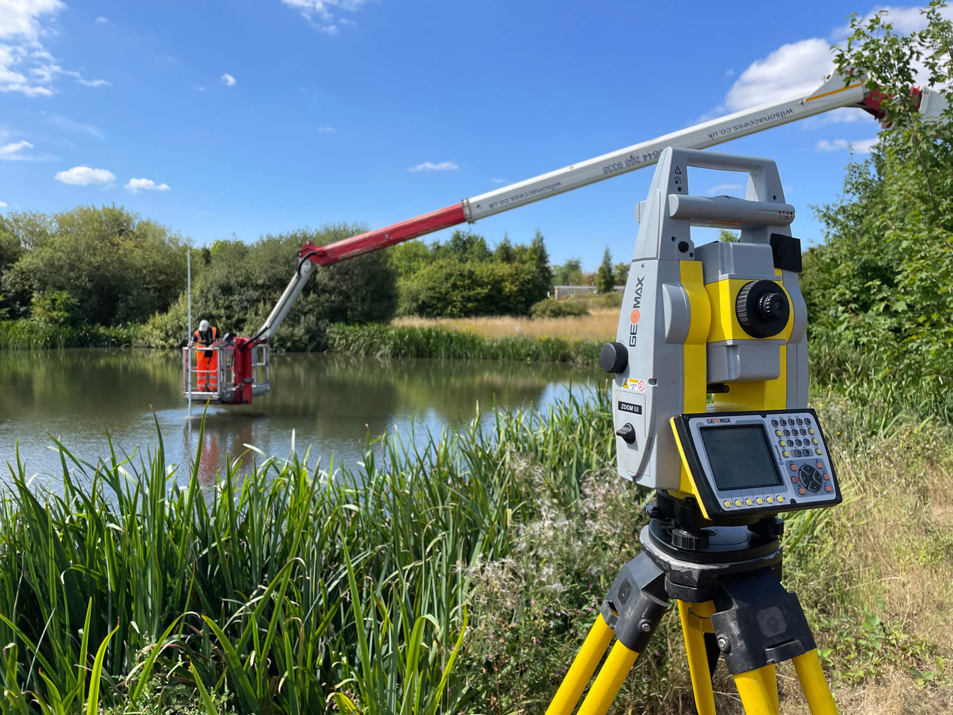
For projects requiring ground-level detail, our land-based topographic surveys capture accurate measurements of all site features, including boundary lines, elevations, and physical structures. Using advanced equipment, such as Trimble S7 total stations and Geomax Zoom 90, we deliver precise data for on-the-ground projects.
Land-based topographic surveys are suitable for:
Our land-based surveys are ideal for general land surveys, property development, and complex areas that benefit from direct ground measurement.
Sky Revolutions’ topographic surveys, whether aerial or land-based, provide a comprehensive view of site features, empowering architects, developers, and engineers to visualise, design, and plan projects confidently.
We deliver data in both 2D and 3D formats and offer a range of supplementary data options, such as photographic imaging, site sections, and spot heights. Our flexible output options ensure you receive the exact data formats you need, including CAD files for every project.
Curious about the results? Read our case study on the topographical survey we completed for Workplace Property.
Need a topographic or topographical survey for your next project?
Contact our team and we’ll provide a detailed proposal tailored to your specific requirements.


Our team will work with you to fully understand your project requirements and help you to develop the very best solution. We’ll meticulously plan every job to ensure that we get it right first time, every time.
Get in touch with us today to discuss your project. You can either contact us using this form and one of the team will get in touch shortly, or you can call the office directly on 01778 560929.