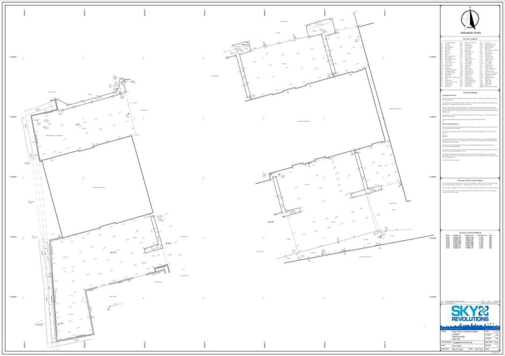
Our surveyors recently undertook a topographic survey in Langtoft, South Kesteven for commercial property management and development company, Workplace Property. The site that required surveying was King Street Industrial Estate, which is owned and managed by our client.
Background
Topographic surveys, also known as land surveys, are essential for mapping and measuring the physical aspects of the earth’s surface, including both natural and man-made features. These surveys play a crucial role in fields such as civil engineering, urban planning, and land development. Our client needed a detailed topographic survey to determine the levels and locations of drainage channels and gullies within specified hard standing areas, as well as details of drainage pipes leading into the ditch adjacent to the site.
Project requirements
The primary objectives were to:
- Map the levels and locations of drainage channels and gullies within the designated hard standing areas.
- Gather detailed information about the drainage pipes entering the adjacent ditch.
- Present the data in a clear, precise format for use in future planning and development.
Methodology
To meet the client’s requirements, our surveyors conducted a traditional topographic survey using advanced equipment and precise techniques:
- Trimble S7 Total Station: The Trimble S7 Total Station was employed to capture accurate measurements of the site. This versatile instrument allowed for precise mapping of the physical features, including the drainage channels and gullies.
- Trimble R8s GPS kit: To ensure the survey was fixed to the national grid, we used the Trimble R8s GPS kit. This equipment provided the necessary georeferencing to align the survey data with national mapping standards.
- Data processing and CAD drawing: Once the field data was captured, our in-house team processed the information and created a detailed 1:200 scale CAD drawing of the site. This drawing included all required details of the drainage channels, gullies, and drainage pipes.
Challenges and solutions
The primary challenge was to ensure the accuracy and precision of the data collected, given the importance of the drainage details for the client’s project. By using the Trimble S7 Total Station and Trimble R8s GPS kit, we were able to achieve high levels of accuracy. Additionally, our team’s expertise in data processing and CAD drawing creation ensured that the final output met all the client’s requirements.
Results
The topographic survey provided the client with a comprehensive and precise map of the drainage channels, gullies, and drainage pipes. The 1:200 scale CAD drawing served as a valuable tool for the client’s future planning and development efforts, offering a clear and detailed representation of the site’s topography.
Conclusion
Our successful completion of this topographic survey underscores our capability to deliver high-quality, accurate, and reliable data for complex land surveying projects. By utilising advanced surveying equipment and expert data processing techniques, we were able to meet the client’s needs effectively.
Does your business require a land survey? Get in touch with our team of experts to discuss your business needs further. We offer both traditional and aerial topographic surveys to suit a wide range of project requirements. To learn more about our aerial topographic surveys and see more of our case studies, visit our website. Discover a day in the life of our excellent team of surveyors and explore the full range of services we offer.