Background
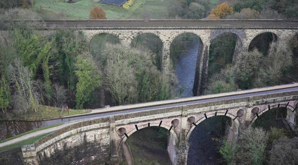
Marple Aqueduct in Stockport is a landmark in British engineering, standing as the highest canal aqueduct in England and the highest masonry-arch aqueduct in Britain. The Canal & River Trust required a comprehensive inspection of the aqueduct to ensure its structural integrity before installing a new parapet to enhance public safety. Arcadis, a global consultancy firm, was responsible for overseeing the project and partnered with Sky Revolutions to conduct an aerial survey of the structure, focusing on the underside of the brickwork arches and the face of the aqueduct.
Project requirements
The primary objectives of the project were:
- Aerial inspection of the brickwork on the underside of the arches and the face of the aqueduct.
- Capturing ultra-high-definition images of the structure to identify any potential defects.
- Overcoming the logistical challenges of inspecting a remote, high-risk location while eliminating the need for scaffolding and manual inspections.
Challenges and solutions
Challenge 1: Remote location & difficult access
- Problem: Marple Aqueduct’s height and positioning over a canal made conventional inspection methods, such as scaffolding or manual surveys, both time-consuming and expensive. Scaffolding in such a remote area posed logistical challenges and risks to workers.
- Solution: Sky Revolutions deployed drones equipped with ultra-high-definition cameras to capture detailed images from difficult-to-reach angles. The drone was able to hover beneath the aqueduct, providing a close-up view of the brickwork without requiring scaffolding. This solution not only reduced costs but also sped up the inspection process significantly.
Challenge 2: Working at height over water
- Problem: Traditional inspections at such heights and over a waterway present safety risks to workers and require additional safety measures, which can be costly and complex.
- Solution: Using drones removed the need for human presence at dangerous heights, eliminating the associated risks. The aerial survey allowed for a safe inspection, with drones being able to navigate precisely and safely to capture detailed data from various angles.
Challenge 3: Capturing detailed structural data
- Problem: The aqueduct’s intricate brickwork and historical structure required high-resolution images that could highlight even the smallest defects. Standard inspection tools might not provide the clarity needed to assess the structure properly.
- Solution: Sky Revolutions deployed drones equipped with ultra-high-definition cameras capable of capturing extremely detailed images. This enabled our client to closely inspect the brickwork for defects and make immediate remediation decisions based on the data captured.
Challenge 4: Time and cost efficiency
- Problem: Traditional methods like scaffolding and manual inspections would have been expensive and taken significantly longer, delaying the project.
- Solution: The aerial drone survey not only saved time by eliminating the need for scaffolding but also cut costs dramatically. The drones were deployed quickly, capturing comprehensive data in a fraction of the time that a manual inspection would have taken.
Methodology
Planning and safety assessment: Prior to the aerial survey, a full safety and risk assessment was conducted to ensure compliance with all necessary regulations. This step was essential given the height and complexity of the site.
Drone deployment: Sky Revolutions used drones equipped with ultra-high-definition cameras to capture precise images of the aqueduct’s underside and brickwork arches. The drones were able to access and inspect parts of the structure that would have been nearly impossible to reach with traditional methods.
Data collection and analysis: The high-resolution images captured by the drones were processed and analysed to identify structural defects. These images provided the Canal & River Trust and Arcadis with valuable insights into the condition of the aqueduct’s brickwork and helped them make informed decisions about remediation.
Results
Sky Revolutions’ drone survey provided Arcadis and the Canal & River Trust with detailed, accurate data on the condition of Marple Aqueduct’s brickwork, allowing for immediate remediation decisions. By avoiding the need for scaffolding or manual inspections, the aerial survey saved both time and costs while significantly reducing safety risks.
The project successfully demonstrated how aerial inspections can overcome challenges such as remote locations and working at height, while also delivering high-quality, actionable data quickly and efficiently.
Conclusion
Sky Revolutions’ aerial inspection of Marple Aqueduct showcased the effectiveness of drone technology in surveying historically significant structures in challenging environments. The ability to capture ultra-high-definition imagery from difficult-to-reach areas allowed Arcadis and the Canal & River Trust to proceed with the project efficiently, ensuring the structural integrity of the aqueduct and enabling safe public access after the parapet installation.
Get in touch
If you’re looking for cost-effective and safe aerial inspection solutions, contact Sky Revolutions today. Our experts are ready to discuss how our drones can help deliver detailed, reliable data for your next project.